|
| at: |
Sabine National Forest |
Data from USFS GIS
 show on map
 animate
Trail users:


Elevation Profile
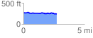
 2.725478 mi
 112.70 ft
 153.13 ft
 -40.43 ft
 1.06 %
GPX Downloads: Track Route
![]()
|
| at: |
Sabine National Forest |
show on map
animate
2.725478 mi
112.70 ft
153.13 ft
-40.43 ft
1.06 %