| at: |
Sabine National Forest |
Data from USFS GIS
 show on map
 animate
Trail users:


Elevation Profile
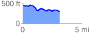
 3.136233 mi
 196.30 ft
 341.23 ft
 -144.93 ft
 2.06 %
GPX Downloads: Track Route
![]()
| at: |
Sabine National Forest |
show on map
animate
3.136233 mi
196.30 ft
341.23 ft
-144.93 ft
2.06 %