| at: |
Sabine National Forest |
Data from USFS GIS
 show on map
 animate
Trail users:


Elevation Profile
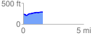
 1.612959 mi
 90.49 ft
 41.12 ft
 49.37 ft
 1.06 %
GPX Downloads: Track Route
![]()
| at: |
Sabine National Forest |
show on map
animate
1.612959 mi
90.49 ft
41.12 ft
49.37 ft
1.06 %