| at: |
Sabine National Forest |
Data from USFS GIS
 show on map
 animate
Trail users:


Elevation Profile
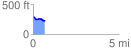
 0.682476 mi
 20.58 ft
 82.37 ft
 -61.79 ft
 2.29 %
GPX Downloads: Track Route
![]()
| at: |
Sabine National Forest |
show on map
animate
0.682476 mi
20.58 ft
82.37 ft
-61.79 ft
2.29 %