|
| at: |
Sabine National Forest |
Data from USFS GIS
 show on map
 animate
Trail users:


Elevation Profile
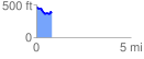
 0.823946 mi
 64.79 ft
 142.95 ft
 -78.16 ft
 3.29 %
GPX Downloads: Track Route
![]()
|
| at: |
Sabine National Forest |
show on map
animate
0.823946 mi
64.79 ft
142.95 ft
-78.16 ft
3.29 %