| at: |
Sabine National Forest |
Data from USFS GIS
 show on map
 animate
Trail users:


Elevation Profile
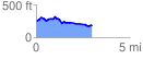
 3.007465 mi
 212.85 ft
 287.32 ft
 -74.47 ft
 1.81 %
GPX Downloads: Track Route
![]()
| at: |
Sabine National Forest |
show on map
animate
3.007465 mi
212.85 ft
287.32 ft
-74.47 ft
1.81 %