| at: |
Sabine National Forest |
Data from USFS GIS
 show on map
 animate
Trail users:


Elevation Profile
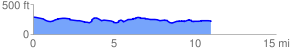
 11.299880 mi
 418.76 ft
 514.72 ft
 -95.95 ft
 0.86 %
GPX Downloads: Track Route
![]()
| at: |
Sabine National Forest |
show on map
animate
11.299880 mi
418.76 ft
514.72 ft
-95.95 ft
0.86 %