| at: |
Sabine National Forest |
Data from USFS GIS
 show on map
 animate
Trail users:


Elevation Profile
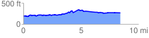
 8.519325 mi
 380.64 ft
 304.06 ft
 76.58 ft
 0.85 %
GPX Downloads: Track Route
![]()
| at: |
Sabine National Forest |
show on map
animate
8.519325 mi
380.64 ft
304.06 ft
76.58 ft
0.85 %