| at: |
Sabine National Forest |
Data from USFS GIS
 show on map
 animate
Trail users:


Elevation Profile
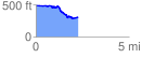
 2.313771 mi
 142.52 ft
 307.44 ft
 -164.91 ft
 2.52 %
GPX Downloads: Track Route
![]()
| at: |
Sabine National Forest |
show on map
animate
2.313771 mi
142.52 ft
307.44 ft
-164.91 ft
2.52 %