| at: |
Sabine National Forest |
Data from USFS GIS
 show on map
 animate
Trail users:


Elevation Profile
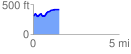
 1.505929 mi
 197.17 ft
 94.29 ft
 102.88 ft
 2.48 %
GPX Downloads: Track Route
![]()
| at: |
Sabine National Forest |
show on map
animate
1.505929 mi
197.17 ft
94.29 ft
102.88 ft
2.48 %