| at: |
Sabine National Forest |
Data from USFS GIS
 show on map
 animate
Trail users:


Elevation Profile
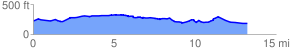
 13.400148 mi
 585.35 ft
 630.42 ft
 -45.06 ft
 0.89 %
GPX Downloads: Track Route
![]()
| at: |
Sabine National Forest |
show on map
animate
13.400148 mi
585.35 ft
630.42 ft
-45.06 ft
0.89 %