| at: |
Sabine National Forest |
Data from USFS GIS
 show on map
 animate
Trail users:


Elevation Profile
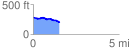
 1.535930 mi
 58.41 ft
 138.74 ft
 -80.33 ft
 1.71 %
GPX Downloads: Track Route
![]()
| at: |
Sabine National Forest |
show on map
animate
1.535930 mi
58.41 ft
138.74 ft
-80.33 ft
1.71 %