| at: |
Sabine National Forest |
Data from USFS GIS
 show on map
 animate
Trail users:


Elevation Profile
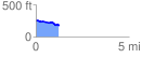
 1.241392 mi
 36.22 ft
 120.95 ft
 -84.72 ft
 1.85 %
GPX Downloads: Track Route
![]()
| at: |
Sabine National Forest |
show on map
animate
1.241392 mi
36.22 ft
120.95 ft
-84.72 ft
1.85 %