| at: |
Sabine National Forest |
Data from USFS GIS
 show on map
 animate
Trail users:


Elevation Profile
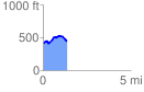
 1.366078 mi
 158.35 ft
 133.87 ft
 24.48 ft
 2.20 %
GPX Downloads: Track Route
![]()
| at: |
Sabine National Forest |
show on map
animate
1.366078 mi
158.35 ft
133.87 ft
24.48 ft
2.20 %