| at: |
Sabine National Forest |
Data from USFS GIS
 show on map
 animate
Trail users:


Elevation Profile
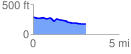
 3.101824 mi
 77.25 ft
 189.79 ft
 -112.54 ft
 1.16 %
GPX Downloads: Track Route
![]()
| at: |
Sabine National Forest |
show on map
animate
3.101824 mi
77.25 ft
189.79 ft
-112.54 ft
1.16 %