|
| at: |
Blue Ridge WMA |
Data from David Muse
 show on map
 animate
Trail users:


Elevation Profile
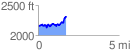
 1.731249 mi
 365.42 ft
 192.78 ft
 172.64 ft
 4.00 %
GPX Downloads: Track Route
![]()
|
| at: |
Blue Ridge WMA |
show on map
animate
1.731249 mi
365.42 ft
192.78 ft
172.64 ft
4.00 %