|
| at: |
Sam Houston National Forest |
Data from USFS GIS
 show on map
 animate
Trail users:


Elevation Profile
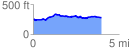
 4.043825 mi
 250.52 ft
 225.03 ft
 25.50 ft
 1.17 %
GPX Downloads: Track Route
![]()
|
| at: |
Sam Houston National Forest |
show on map
animate
4.043825 mi
250.52 ft
225.03 ft
25.50 ft
1.17 %