|
| at: |
Blue Ridge WMA |
Data from David Muse
 show on map
 animate
Trail users:


Elevation Profile
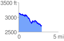
 2.915604 mi
 521.98 ft
 933.31 ft
 -411.33 ft
 6.06 %
GPX Downloads: Track Route
![]()
|
| at: |
Blue Ridge WMA |
show on map
animate
2.915604 mi
521.98 ft
933.31 ft
-411.33 ft
6.06 %