|
| at: |
Sam Houston National Forest |
Data from USFS GIS
 show on map
 animate
Trail users:


Elevation Profile
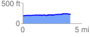
 4.040192 mi
 73.86 ft
 38.39 ft
 35.48 ft
 0.35 %
GPX Downloads: Track Route
![]()
|
| at: |
Sam Houston National Forest |
show on map
animate
4.040192 mi
73.86 ft
38.39 ft
35.48 ft
0.35 %