| at: |
Sam Houston National Forest |
Data from USFS GIS
 show on map
 animate
Trail users:


Elevation Profile
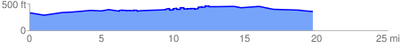
 20.211386 mi
 729.04 ft
 690.87 ft
 38.17 ft
 0.68 %
GPX Downloads: Track Route
![]()
| at: |
Sam Houston National Forest |
show on map
animate
20.211386 mi
729.04 ft
690.87 ft
38.17 ft
0.68 %