| at: |
Sam Houston National Forest |
Data from USFS GIS
 show on map
 animate
Trail users:


Elevation Profile
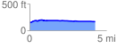
 4.265575 mi
 76.03 ft
 53.43 ft
 22.59 ft
 0.34 %
GPX Downloads: Track Route
![]()
| at: |
Sam Houston National Forest |
show on map
animate
4.265575 mi
76.03 ft
53.43 ft
22.59 ft
0.34 %