|
| at: |
Blue Ridge WMA |
Data from David Muse
 show on map
 animate

Trail users:


Elevation Profile
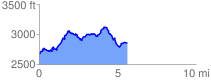
 5.704625 mi
 1265.88 ft
 1071.42 ft
 194.46 ft
 4.20 %
GPX Downloads: Track Route
![]()
|
| at: |
Blue Ridge WMA |
show on map
animate
5.704625 mi
1265.88 ft
1071.42 ft
194.46 ft
4.20 %