|
| at: |
Sam Houston National Forest |
Data from USFS GIS
 show on map
 animate
Trail users:


Elevation Profile
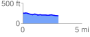
 3.028621 mi
 49.37 ft
 109.89 ft
 -60.51 ft
 0.69 %
GPX Downloads: Track Route
![]()
|
| at: |
Sam Houston National Forest |
show on map
animate
3.028621 mi
49.37 ft
109.89 ft
-60.51 ft
0.69 %