|
| at: |
Sam Houston National Forest |
Data from USFS GIS
 show on map
 animate
Trail users:


Elevation Profile
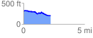
 2.258554 mi
 109.69 ft
 212.00 ft
 -102.31 ft
 1.78 %
GPX Downloads: Track Route
![]()
|
| at: |
Sam Houston National Forest |
show on map
animate
2.258554 mi
109.69 ft
212.00 ft
-102.31 ft
1.78 %