| at: |
Sam Houston National Forest |
Data from USFS GIS
 show on map
 animate
Trail users:


Elevation Profile
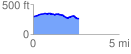
 2.670307 mi
 120.99 ft
 151.60 ft
 -30.61 ft
 1.08 %
GPX Downloads: Track Route
![]()
| at: |
Sam Houston National Forest |
show on map
animate
2.670307 mi
120.99 ft
151.60 ft
-30.61 ft
1.08 %