| at: |
Sam Houston National Forest |
Data from USFS GIS
 show on map
 animate
Trail users:


Elevation Profile
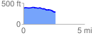
 2.600751 mi
 46.75 ft
 143.65 ft
 -96.90 ft
 1.05 %
GPX Downloads: Track Route
![]()
| at: |
Sam Houston National Forest |
show on map
animate
2.600751 mi
46.75 ft
143.65 ft
-96.90 ft
1.05 %