| at: |
Sam Houston National Forest |
Data from USFS GIS
 show on map
 animate
Trail users:


Elevation Profile
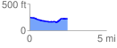
 2.520405 mi
 81.80 ft
 110.77 ft
 -28.97 ft
 0.83 %
GPX Downloads: Track Route
![]()
| at: |
Sam Houston National Forest |
show on map
animate
2.520405 mi
81.80 ft
110.77 ft
-28.97 ft
0.83 %