| at: |
Sam Houston National Forest |
Data from USFS GIS
 show on map
 animate
Trail users:


Elevation Profile
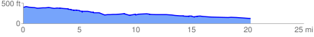
 20.470829 mi
 433.44 ft
 697.48 ft
 -264.04 ft
 0.65 %
GPX Downloads: Track Route
![]()
| at: |
Sam Houston National Forest |
show on map
animate
20.470829 mi
433.44 ft
697.48 ft
-264.04 ft
0.65 %