| at: |
Sam Houston National Forest |
Data from USFS GIS
 show on map
 animate
Trail users:


Elevation Profile
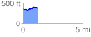
 1.281766 mi
 123.88 ft
 117.51 ft
 6.37 ft
 1.83 %
GPX Downloads: Track Route
![]()
| at: |
Sam Houston National Forest |
show on map
animate
1.281766 mi
123.88 ft
117.51 ft
6.37 ft
1.83 %