| at: |
Sam Houston National Forest |
Data from USFS GIS
 show on map
 animate
Trail users:


Elevation Profile
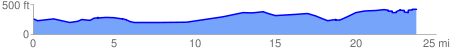
 23.948672 mi
 872.97 ft
 721.96 ft
 151.00 ft
 0.69 %
GPX Downloads: Track Route
![]()
| at: |
Sam Houston National Forest |
show on map
animate
23.948672 mi
872.97 ft
721.96 ft
151.00 ft
0.69 %