| at: |
Sam Houston National Forest |
Data from USFS GIS
 show on map
 animate
Trail users:


Elevation Profile
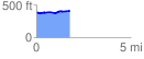
 1.792835 mi
 74.12 ft
 52.41 ft
 21.72 ft
 0.78 %
GPX Downloads: Track Route
![]()
| at: |
Sam Houston National Forest |
show on map
animate
1.792835 mi
74.12 ft
52.41 ft
21.72 ft
0.78 %