| at: |
Sam Houston National Forest |
Data from USFS GIS
 show on map
 animate
Trail users:

Elevation Profile
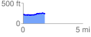
 1.856230 mi
 160.87 ft
 160.87 ft
 0.00 ft
 1.64 %
GPX Downloads: Track Route
![]()
| at: |
Sam Houston National Forest |
show on map
animate
1.856230 mi
160.87 ft
160.87 ft
0.00 ft
1.64 %