|
| at: |
Blue Ridge WMA |
Data from David Muse
 show on map
 animate
Trail users:


Elevation Profile
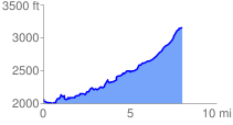
 8.094224 mi
 1655.38 ft
 565.22 ft
 1090.16 ft
 3.87 %
GPX Downloads: Track Route
Trailheads:
 Noontootla - Fellowship Primitive Church