| at: |
The Great Valley Trans North Georgia |
Data from David Muse
 show on map
 animate
Trail users:


Elevation Profile
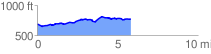
 5.880374 mi
 344.64 ft
 263.60 ft
 81.04 ft
 1.11 %
GPX Downloads: Track Route
![]()
| at: |
The Great Valley Trans North Georgia |
show on map
animate
5.880374 mi
344.64 ft
263.60 ft
81.04 ft
1.11 %