|
| at: |
Blue Ridge WMA |
Data from David Muse
 show on map
 animate

Trail users:


Elevation Profile
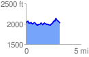
 3.111193 mi
 480.58 ft
 488.01 ft
 -7.43 ft
 2.97 %
GPX Downloads: Track Route
![]()
|
| at: |
Blue Ridge WMA |
show on map
animate
3.111193 mi
480.58 ft
488.01 ft
-7.43 ft
2.97 %