| at: |
Yellow River Park |
Data from David Muse
 show on map
 animate
Trail users:


Elevation Profile
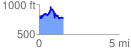
 1.564332 mi
 410.73 ft
 427.15 ft
 -16.43 ft
 5.17 %
GPX Downloads: Track Route
Trailheads:
 Yellow River Equestrian Parking Lot
![]()
| at: |
Yellow River Park |
show on map
animate
1.564332 mi
410.73 ft
427.15 ft
-16.43 ft
5.17 %
Yellow River Equestrian Parking Lot