|
| at: |
Blue Ridge WMA |
Data from David Muse
 show on map
 animate
Trail users:


Elevation Profile
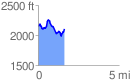
 1.624719 mi
 354.28 ft
 394.59 ft
 -40.30 ft
 4.60 %
GPX Downloads: Track Route
![]()
|
| at: |
Blue Ridge WMA |
show on map
animate
1.624719 mi
354.28 ft
394.59 ft
-40.30 ft
4.60 %