|
| at: |
Blue Ridge WMA Amicalola/Nimblewill/Tickanetley |
Data from David Muse
 show on map
 animate
Trail users:


Elevation Profile
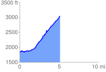
 5.158672 mi
 1486.44 ft
 282.72 ft
 1203.72 ft
 5.46 %
GPX Downloads: Track Route
![]()
|
| at: |
Blue Ridge WMA Amicalola/Nimblewill/Tickanetley |
show on map
animate
5.158672 mi
1486.44 ft
282.72 ft
1203.72 ft
5.46 %