| at: |
Rocky Hill Ranch |
Data from Jason Sager
 show on map
 animate
Trail users:


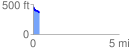
Elevation Profile
 0.353202 mi
 42.20 ft
 98.90 ft
 -56.70 ft
 5.30 %
GPX Downloads: Track Route
![]()
| at: |
Rocky Hill Ranch |
show on map
animate
0.353202 mi
42.20 ft
98.90 ft
-56.70 ft
5.30 %