|
| at: |
Gaddistown/Canada Creek |
Data from David Muse
 show on map
 animate
Trail users:

Elevation Profile
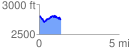
 1.348576 mi
 265.35 ft
 313.38 ft
 -48.03 ft
 4.40 %
GPX Downloads: Track Route
![]()
|
| at: |
Gaddistown/Canada Creek |
show on map
animate
1.348576 mi
265.35 ft
313.38 ft
-48.03 ft
4.40 %