|
| at: |
Sumter National Forest - Long Cane District |
Data from USFS GIS
 show on map
 animate
Trail users:


Elevation Profile
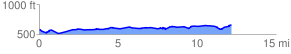
 12.284163 mi
 553.64 ft
 457.88 ft
 95.76 ft
 0.85 %
GPX Downloads: Track Route
![]()
|
| at: |
Sumter National Forest - Long Cane District |
show on map
animate
12.284163 mi
553.64 ft
457.88 ft
95.76 ft
0.85 %