| at: |
Sumter National Forest - Long Cane District |
Data from USFS GIS
 show on map
 animate
Trail users:


Elevation Profile
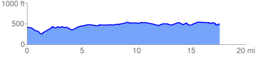
 17.788311 mi
 1115.16 ft
 991.46 ft
 123.70 ft
 1.19 %
GPX Downloads: Track Route
![]()
| at: |
Sumter National Forest - Long Cane District |
show on map
animate
17.788311 mi
1115.16 ft
991.46 ft
123.70 ft
1.19 %