| at: |
Sumter National Forest - Long Cane District |
Data from USFS GIS
 show on map
 animate
Trail users:


Elevation Profile
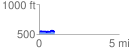
 0.951648 mi
 49.46 ft
 41.75 ft
 7.71 ft
 0.98 %
GPX Downloads: Track Route
![]()
| at: |
Sumter National Forest - Long Cane District |
show on map
animate
0.951648 mi
49.46 ft
41.75 ft
7.71 ft
0.98 %