| at: |
Sumter National Forest - Long Cane District |
Data from USFS GIS
 show on map
 animate
Trail users:


Elevation Profile
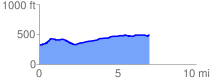
 7.031676 mi
 371.29 ft
 199.07 ft
 172.22 ft
 1.00 %
GPX Downloads: Track Route
![]()
| at: |
Sumter National Forest - Long Cane District |
show on map
animate
7.031676 mi
371.29 ft
199.07 ft
172.22 ft
1.00 %