| at: |
Sumter National Forest - Long Cane District |
Data from USFS GIS
 show on map
 animate
Trail users:

Elevation Profile
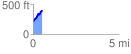
 0.536835 mi
 208.27 ft
 19.39 ft
 188.88 ft
 7.35 %
GPX Downloads: Track Route
![]()
| at: |
Sumter National Forest - Long Cane District |
show on map
animate
0.536835 mi
208.27 ft
19.39 ft
188.88 ft
7.35 %