| at: |
Sumter National Forest - Long Cane District |
Data from USFS GIS
 show on map
 animate
Trail users:


Elevation Profile
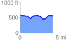
 4.098028 mi
 340.93 ft
 357.16 ft
 -16.23 ft
 1.65 %
GPX Downloads: Track Route
![]()
| at: |
Sumter National Forest - Long Cane District |
show on map
animate
4.098028 mi
340.93 ft
357.16 ft
-16.23 ft
1.65 %