| at: |
Sumter National Forest - Long Cane District |
Data from USFS GIS
 show on map
 animate
Trail users:


Elevation Profile
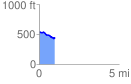
 0.980620 mi
 34.63 ft
 120.15 ft
 -85.52 ft
 2.32 %
GPX Downloads: Track Route
![]()
| at: |
Sumter National Forest - Long Cane District |
show on map
animate
0.980620 mi
34.63 ft
120.15 ft
-85.52 ft
2.32 %