|
| at: |
Sumter National Forest - Long Cane District |
Data from USFS GIS
 show on map
 animate
Trail users:


Elevation Profile
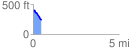
 0.497721 mi
 23.75 ft
 158.40 ft
 -134.64 ft
 6.03 %
GPX Downloads: Track Route
![]()
|
| at: |
Sumter National Forest - Long Cane District |
show on map
animate
0.497721 mi
23.75 ft
158.40 ft
-134.64 ft
6.03 %