|
| at: |
Sumter National Forest - Long Cane District |
Data from USFS GIS
 show on map
 animate
Trail users:


Elevation Profile
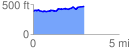
 2.971619 mi
 211.45 ft
 124.61 ft
 86.85 ft
 1.35 %
GPX Downloads: Track Route
![]()
|
| at: |
Sumter National Forest - Long Cane District |
show on map
animate
2.971619 mi
211.45 ft
124.61 ft
86.85 ft
1.35 %