| at: |
Sumter National Forest - Long Cane District |
Data from USFS GIS
 show on map
 animate
Trail users:


Elevation Profile
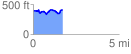
 1.706828 mi
 195.01 ft
 182.74 ft
 12.27 ft
 2.16 %
GPX Downloads: Track Route
![]()
| at: |
Sumter National Forest - Long Cane District |
show on map
animate
1.706828 mi
195.01 ft
182.74 ft
12.27 ft
2.16 %